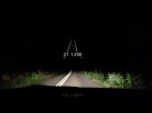
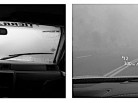
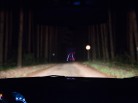
We've all used the GPS software in our phones but I was hoping for something a little different when I came across the HUDWAY GPS app. HUDWAY uses Google maps, which we all know by those funny cars driving around town with a spaceship on top, is regularly updated. What makes HUDWAY different is that it shows the image in reverse which you can see on the inside of your windscreen. Yup - just like a fighter jet or high end luxury car you too can benefit from a heads up display in your car.
The Interface
This is a good time to mention that the app is available for both iOS and Android. Once you download the app, which currently is 10.6 MB, you'll be asked to use a sign in. I chose Facebook but really this doesn't affect the software at all. The first step of the software is "Start HUDWAY in low visibility conditions". Ehh? Well considering I was traveling from Seattle south through California before heading to the southwest I figured this was quite doable. Wouldn't you know it that the week preceding this test that I was in Seattle was the driest and sunniest week on record?
One feature that I think makes HUDWAY light years ahead of its competition, besides being in your line of sight on the windshield, is the fact that you don't actually have to have an internet connection on your phone for it to work. Through the wonders of modern science we have GPS in our phones which can be even more accurate than using cell tower triangulation to get you to your destination. Of course if you are on a major roadway it would be nearly impossible not to have signal these days so that helps too. You will need an internet connection to lay out your route as you have to connect to Google's data. Save your route in the app and now if you happen to find yourself in the Styx you will be OK. If you've used Google maps before and worked with its ability to change way points to create a route you are miles ahead.
So How Does It Work?
Leaving Seattle on I-5 I found that there was too much sunlight to use this app in the daytime. Remember that first step? Start HUDWAY in low light conditions? You guessed it - its next to invisible on a sunny day. OK then. Enter display options and get rid of the reverse view and now you can stare at your phone in an ordinary way. My next problem was that its nearly impossible to keep my phone with its case stationary on my dash. Looking at a pic in the App Store I could see the phone setting on a soft object to help keep it stationary. Enter a T-shirt which worked beautifully. As the day darkened the GPS became very visible. Obviously turning up the brightness on your phone helps quite well but keep in mind this is not a dedicated HUD projector like some luxury cars come equipped with.
The navigation itself is very good. It gave me plenty of warning when I had turns coming. On the display are your speed, the curve of the road, and the distance to turns or curves are displayed. Curves are highlighted in red which I really appreciated in the Mt Shasta area. Here the speeds go from 60 to 35 in the curves and the signage isn't all that great. Luckily I have a great suspension, nerves of steel, and new tires but I learned quickly that HUDWAY's warnings should be heeded. I kept my car's GPS going - which by the way doesn't need a phone connection as its routes are stored on a DVD in the trunk. How do the two compare? Both can display turn to turn but my car can display a map with a topo view. Sadly I can't trust it very well for side roads but Interstates are set in stone, almost quite literally, but here is where HUDWAY is better - if you plan those side roads into your route initially. Which did I trust? Since I didn't want to end up back in Seattle it was HUDWAY. Also - and this isn't well explained in its App Store description - you don't have to project HUDWAY on the windscreen. You have a display option - now place it in a cradle and you are set to go. The HUD effect is cool but won't work well in the sun. Most people travel in the sunlight but I can see where this is a huge advantage on winding roads and bad weather.
Conclusions
Sadly in car GPS systems become relics without regular updates. Manufacturers still rely on DVD based mapping and at a cost of close to $200 on eBay its not a cheap update every year. HUDWAY not only can get regular app updates but Google is constantly updating their maps to include new residential and commercial areas. How does HUDWAY compare to built in GPS apps in phones? I don't like the voice prompts on those as often they tell you to turn or change lanes at the last possible moment. At 75 MPH on a highway its no time to try to change lanes to get the right exit lined up.
I'm going to recommend this app as so far its one of the best I've used for day to day operation. Give it a spin and see if it works for you. I've gone against the developer's site recommendation that no special film is required and found a dark tinted clear plastic sheet which I can throw on my dash. It displays the image very nicely and doesn't affect visibility in the day. At night I take it off and enjoy how HUDWAY was meant to work. There are voice prompts but I prefer just scanning it visually from time to time. Why didn't it get a perfect score - you'll have to stop and make sure you have an internet connection to make route changes should you discover roadwork ahead or deteriorating weather. You can input multiple routes when planning your trip but that wasn't practical for me for such a long trip.


